TOP 25 HIKES IN MASSACHUSETTS
I am proud to present what I believe to be the top 25 hikes in Massachusetts! This list is based upon a mix of personal experience of hiking throughout the state for the past fifteen years and a thorough review of dozens of websites and just about every hiking guidebook that has been published on hiking in Massachusets over the past two decades.
Each of these hikes is exceptionally memorable - you can't go wrong with any of them.
Take note that this list is in random order - it is not sorted by rank.
Follow New England Waterfalls on Facebook! 
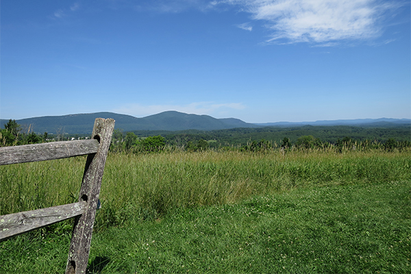
BARTHOLOMEW'S COBBLE RESERVATION / HULBURT'S HILL
| STATE |
TOTAL MILEAGE |
DIFFICULTY |
NOTES & HIGHLIGHTS |
| MA |
1.3 miles one-way to Hulburt's Hill; there are a total of 5.0 total miles of trails in the reservation |
Easy / Moderate |
this highly enjoyable hike climbs moderately along the Tractor Path for 1.3 miles to beautiful northward-facing views from the field atop Hulburt's Hill; for a trail map of this lovely Trustees of Reservation property, click here; the trailhead and visitor center for the reservation is on Weatogue Road in Ashley Falls |
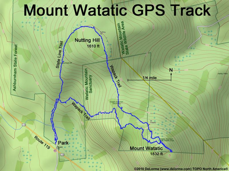
MOUNT WATATIC
| STATE |
TOTAL MILEAGE |
DIFFICULTY |
NOTES & HIGHLIGHTS |
| MA |
3.0 mile loop |
Moderate / Difficult |
Mount Watatic offers some of the finest views in central Massachusetts; portions of the Wapack Trail are fairly steep, so you may want to avoid this trail when it's wet or icy; the trailhead is on MA 119 (Rindge State Road) in Ashburnham; here's a trail map that shows you the loop, which you can hike either clockwise or counterclockwise (I recommend counterclockwise since the southern portion of the Wapack Trail is much steeper than the northern portion or the State Line Trail) |
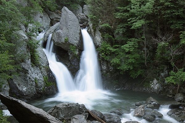
BASH BISH FALLS
| STATE |
TOTAL MILEAGE |
DIFFICULTY |
NOTES & HIGHLIGHTS |
| MA |
0.8 miles
round-trip |
Easy / Moderate |
often described as 'the state's most dramatic waterfall,' Bash Bish Falls is a segmented 80-foot drop of Bash Bish Brook; these falls are perhaps the most well-known and frequently photographed waterfall in Massachusetts; A mighty boulder splits the falls into two sections. Immediately after, the walls surrounding both sides of the falls ricochet the water back together just before crashing into a pool below; there are two trailheads for the falls - one in MA and one in NY |
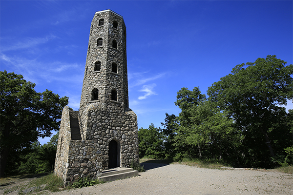
LYNN WOODS RESERVATION
| STATE |
TOTAL MILEAGE |
DIFFICULTY |
NOTES & HIGHLIGHTS |
| MA |
Varies based on trails used |
Easy / Moderate |
Lynn Woods offers one of the premier hiking and mountain biking destinations in eastern Massachusetts; when open, a historic stone tower offers great views of the Boston skyline (in the past, it has only been open on select Saturdays in summer); bring a flashlight in case you find 'Dungeon Rock' (a cave that is sometimes open on Saturdays in summer); don't let the fact that this park is located in the city of Lynn turn you off...it is a fantastic place and urban areas all over the country should be jealous of it |
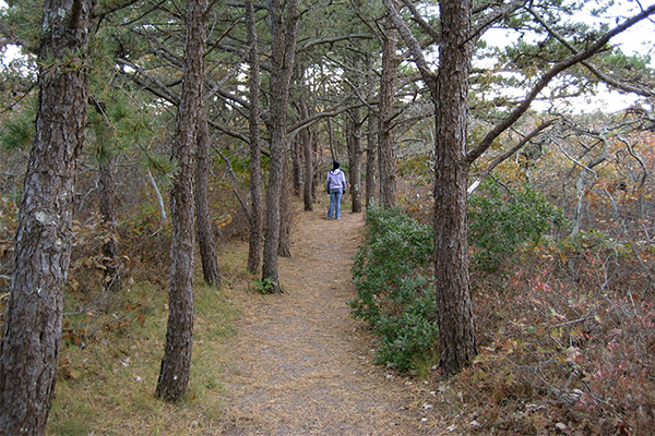
ATLANTIC WHITE CEDAR SWAMP TRAIL
| STATE |
TOTAL MILEAGE |
DIFFICULTY |
NOTES & HIGHLIGHTS |
| MA |
1.2 mile loop |
Easy / Moderate |
this is one of Cape Cod's finest easy day hikes; walk a boardwalk trail though an interesting white cedar swamp; the trailhead is at the Marconi Station Area of South Wellfleet (Marconi Station Road); some portions of the trail are a bit sandy |
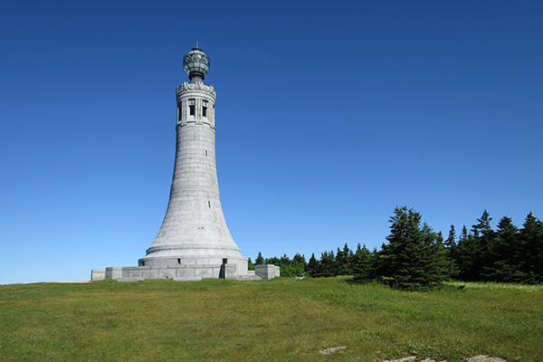
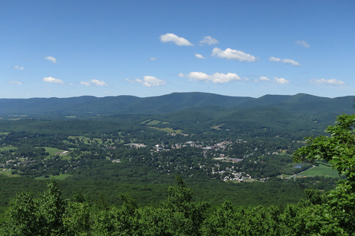
MOUNT GREYLOCK / MOUNT GREYLOCK STATE RESERVATION
| STATE |
TOTAL MILEAGE |
DIFFICULTY |
NOTES & HIGHLIGHTS |
| MA |
Varies based on trails used |
Difficult |
there are dozens of miles of trails on Mount Greylock, which is the highpoint of Massachusetts; the Appalachian Trail also crosses the park; to understand all of your hiking and backpacking options in this large reservation, consult the trail map of the Mount Greylock State Reservation here; there are many waterfalls on the slopes of Mt. Greylock that can be explored as well, including March Cataract Falls, Deer Hill Falls, Falls on the Bellows Pipe Trail, Pecks Falls, and Money Brook Falls; take note that you can also drive to the summit of Mt. Greylock, but it's more fun to hike it and also enjoy the views on the way up |
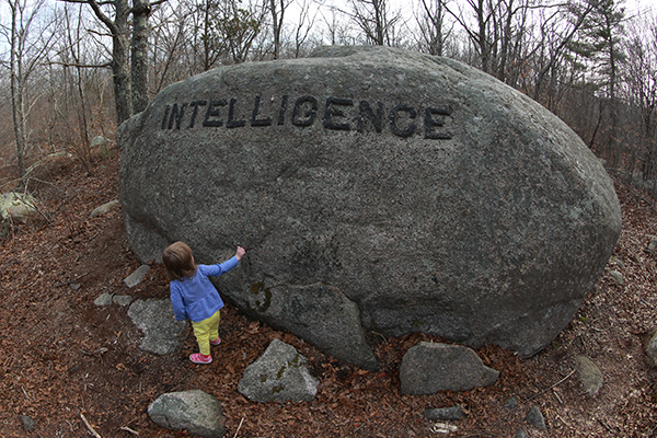
DOGTOWN / BABSON BOULDERS
| STATE |
TOTAL MILEAGE |
DIFFICULTY |
NOTES & HIGHLIGHTS |
| MA |
Varies based on trails used |
Easy / Moderate |
Dogtown offers arguably the best hiking on Cape Ann; don't miss the Whale's Jaw or the famous Babson Boulders (more than 30 boulders with words of advice and inspiration carved deep into them); this conservation park is extremely large, so find and bring a good trail map; here is a good map that shows the approximate location of most of the Babson Boulders |
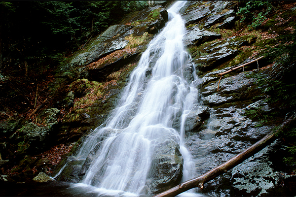
MOUNT RACE / MOUNT EVERETT / RACE BROOK FALLS
| STATE |
TOTAL MILEAGE |
DIFFICULTY |
NOTES & HIGHLIGHTS |
| MA |
7.0 miles
round-trip |
Difficult |
the 7.0 mile hike I have suggested here includes the hike up scenic Mt. Race and Mt. Everett; at least five noteworthy waterfalls and two summits with great views are experienced on this trail; backcountry tentsites are available at Race Brook and Laurel Ridge tentsites; the trailhead for this hike is on MA 41 just north of the Connecticut/Massachusetts border; you can also do this hike as a traverse by using two vehicles and starting at the East Street / Mount Washington Road trailhead in Connecticut just south of the MA/CT border (hike east to the Appalachian Trail and then hike north) |
APPALACHIAN TRAIL ('AT')
| STATE |
TOTAL MILEAGE |
DIFFICULTY |
NOTES & HIGHLIGHTS |
| MA |
up to 90.2-miles
one-way
(shorter day hike options are possible) |
Moderate to Difficult
(depending upon which section(s) are hiked) |
90.2 miles of the 2,190 mile-long Appalachian Trail reside in Massachusetts; the elevation of the AT in Massachusetts ranges from 650ft to 3,491ft; there are many overnight shelters and tentsites along the way; the best sections of the AT in Massachusetts are in the southern and northern portions of the state (the central section is less crowded but also less interesting); the very best highlights of the AT in Massachusetts include Mt. Race and Mt. Greylock |
PINE COBBLE & EAST MOUNTAIN
| STATE |
TOTAL MILEAGE |
DIFFICULTY |
NOTES & HIGHLIGHTS |
| MA |
3.2 miles round-trip |
Moderate |
this is an enjoyable hike to good views of the Hoosic River Valley; the trailhead for this hike is on Pine Cobble Road in Williamstown |
BAY CIRCUIT TRAIL ('BCT')
| STATE |
TOTAL MILEAGE |
DIFFICULTY |
NOTES & HIGHLIGHTS |
| MA |
up to 230-miles
one-way
(shorter day hike options are possible) |
Easy / Moderate
(the difficulty depending upon which section(s) of the trail is hiked) |
the BCT is a fantastic and varied 230-mile trail that loops around Boston; most will use two vehicles and hike it in 5-12 mile segments; this trail is impossible not to enjoy since it passes through dozens of conservation areas, farms, historical areas, and many other interesting natural and man-made environments; a detailed map and a turn-by-turn trail instructions (which can be found on the website of the BCT) is recommended as not all areas are posted well with trail markers |
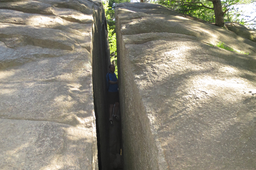
PURGATORY CHASM STATE RESERVATION
| STATE |
TOTAL MILEAGE |
DIFFICULTY |
NOTES & HIGHLIGHTS |
| MA |
0.5 miles
round-trip |
Moderate |
come here and explore the fun rock formations of one of Massachusetts' finest state parks; if you like boulder caves and/or rock scrambling, you will find no better place in southern New England; rock walls tower to 70 feet and are popular with skilled rock climbers; the park also has picnic tables and a nice playground for kids; there are some officially marked hiking trails within the park, but it's more fun to just clamber up and down all the rocks; this is not a safe place for very young kids (I wouldn't bring a kid here that's under 4 unless you have them on a kids' leash); don't miss trying to squeeze through the Fat Man's Misery (shown in the picture below) |
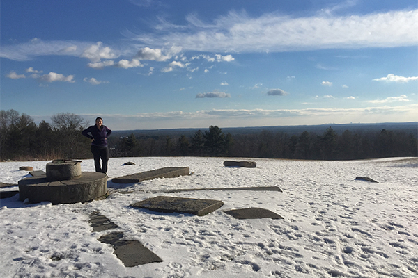
WARD RESERVATION
| STATE |
TOTAL MILEAGE |
DIFFICULTY |
NOTES & HIGHLIGHTS |
| MA |
there are 10 miles of trails in the reservation |
Easy / Moderate |
highlights of this reservation include interesting granite stones and good views of Boston from atop Holt Hill; another trail that stems from the parking lot on Prospect Road visits a bog; this reservation is located in Andover and is one of the best of the Trustees of Reservations' 110+ managed properties in Massachusets |
ALANDER MOUNTAIN
| STATE |
TOTAL MILEAGE |
DIFFICULTY |
NOTES & HIGHLIGHTS |
| MA |
Varies based on trails used |
Moderate / Difficult |
there are several routes to climb this mountain, which provides some of the best views in southwestern Massachusetts; you can hike from Bash Bish Falls State Park, from East Street, or from the Robert Brook Trail from New York; here's a trail map to see all your trail options; there is a cabin (free; first come, first served) that you can stay in overnight near the summit, but it's in rough shape and could use some rehabilitation |
ROBERT FROST TRAIL
| STATE |
TOTAL MILEAGE |
DIFFICULTY |
NOTES & HIGHLIGHTS |
| MA |
up to 47-miles
one-way
(shorter day hike options are possible) |
Moderate to Difficult |
this beloved footpath runs from South Hadley to Wendell State Forest, passing several scenic attractions, including Mount Toby and the Holyoke Range; the trail passes through the following towns: Hadley, South Hadley, Amherst, Granby, Belchertown, Pelham, Shutesbury, Leverett, Sunderland, Wendell and Montague |
BLUE HILLS RESERVATION
| STATE |
TOTAL MILEAGE |
DIFFICULTY |
NOTES & HIGHLIGHTS |
| MA |
there are more than 125 miles of trails in the reservation |
Easy / Moderate |
it's truly amazing that a reservation so close to Boston has withstood development and has more than 125 miles of trails; this reservation offers a variety of interesting trails, some of which offer views of the Boston skyline; the Appalachian Mountain Club rents cabin rentals and campsites near Ponkapag Camp within the park (information on those facilities can be found here) |
GREAT ISLAND TRAIL
| STATE |
TOTAL MILEAGE |
DIFFICULTY |
NOTES & HIGHLIGHTS |
| MA |
up to 3.5 miles
one-way |
Easy / Moderate |
this is perhaps Cape Cod's wildest trail; you'll walk miles of deserted beach, which means you may see all sorts of treasures of the sea that get deposited onto the beach (be aware that you may also see some dead animals from time to time too) |
METACOMET-MONADNOCK TRAIL ('M&M')
| STATE |
TOTAL MILEAGE |
DIFFICULTY |
NOTES & HIGHLIGHTS |
| MA |
up to 114-miles
one-way
(shorter day hike options are possible) |
Easy to Moderate
(depending upon which section(s) of the trail is hiked) |
this rural and scenic trail travels in a north/south direction from the town of Southwick in central Massachusetts to the summit of Mt. Monadnock in New Hampshire; if you are looking for an even longer backpacking trip, this trail also connects with the Metacomet Trail in Connecticut and the Monadnock-Sunapee Greenway Trail in New Hampshire; highlights of the Metacomet-Monadnock Trail include the summits of Mount Tom, Mount Holyoke, and Mount Monadnock, along with the firetower atop Mt. Grace, several waterfalls and other natural and historical features |
MIDDLESEX FELLS RESERVATION
| STATE |
TOTAL MILEAGE |
DIFFICULTY |
NOTES & HIGHLIGHTS |
| MA |
there are more than 100 miles of trails in the reservation |
Easy / Moderate |
there are many nice trails in this large reservation, including the Rock Circuit Trail and the Skyline Trail; the Rock Circuit Trail provides the finest views; there are over 100 miles of trails in this huge reservation, and so you can easily put together a 10+ mile hike if you want to (the Skyline Trail along is about 7.5 miles); if you have a friendly dog, you must visit the Sheepfold at some point (it's a 10-acre open field that often has dozens or even hundreds of dogs playing) |
MIDSTATE TRAIL
| STATE |
TOTAL MILEAGE |
DIFFICULTY |
NOTES & HIGHLIGHTS |
| MA |
up to 95-miles
one-way
(shorter day hike options are possible) |
Easy to Moderate
(depending upon which section(s) of the trail is hiked) |
this long-distance hiking trail in central Massachusetts travels in a north/south directions for 95 miles from the town of Douglas to the town of Ashburnham; highlights of this trail include five overnight shelters and beautiful views atop Mt. Watatic and Mt. Wachusett; there are many day hiking opportunities if you don't want to take the full journey; excellent information and suggested day hikes along the trail can be found at the Midstate Trail's official website here |
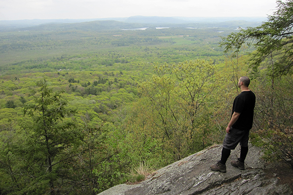
MONUMENT MOUNTAIN
| STATE |
TOTAL MILEAGE |
DIFFICULTY |
NOTES & HIGHLIGHTS |
| MA |
2.3 mile loop
(slightly longer options are also available) |
Moderate |
this is one of the best day hikes in the Berkshires; the ledges on this mountain provide good scenic views; there's a seasonal waterfall here if you visit after heavy rains; the trailhead for the Monument Mountain Reservation is on MA 7 (Stockbridge Road) in Great Barrington; there are several ways you can hike this mountain, so take a look at the trail map here to see your options |
MOUNT TOM
| STATE |
TOTAL MILEAGE |
DIFFICULTY |
NOTES & HIGHLIGHTS |
| MA |
1.0 miles one-way |
Moderate |
hike along the Beau Bridge Trail & M&M Trail within the Mount Tom State Reservation up to an lookout tower that provides good views of the Connecticut Valley; there are 22 miles of trails in the reservation if you are looking to get more miles of hiking in; Mount Tom is a popular place for watching hawks in the fall |
MOUNT WACHUSETT
| STATE |
TOTAL MILEAGE |
DIFFICULTY |
NOTES & HIGHLIGHTS |
| MA |
Varies based on trails used |
Moderate |
there are many hiking routes within the Mount Wachusett State Reservation; to understand your trail options, refer to the trail map here; several trails offer scenic views; Mount Wachusett is one of the major highlights of the Midstate Trail |
TULLY TRAIL
| STATE |
TOTAL MILEAGE |
DIFFICULTY |
NOTES & HIGHLIGHTS |
| MA |
22-mile loop
(shorter day hike options are possible) |
Easy to Moderate
(depending upon which section(s) of the trail is hiked) |
this fun and varied trail can be section hiked or done as a 1-night backpacking trip using the Royalston Falls Shelter (free; first-come, first-served) or the walk-in campsites at Tully Lake Campground; highlights of the Tully Trail include three waterfalls (Doane's Falls, Spirit Falls, Royalston Falls) plus scenic views on Tully Mountain; extremely strong hikers will often try to do the entire loop in one day; be aware that portions of the trail near Tully Lake may be flooded in early spring or after heavy rainstorms; a trail map can be found here |
MOUNT HOLYOKE / MOUNT HOLYOKE RANGE
| STATE |
TOTAL MILEAGE |
DIFFICULTY |
NOTES & HIGHLIGHTS |
| MA |
Varies depending upon route chosen |
Moderate |
hike to and along open ledges providing excellent views along the Holyoke Range; Mt. Holyoke offers great views of the Connecticut River Valley; there are several adjacent state parks and conservation properties in this area, and so many hiking options are possible; take note that you can drive to the summit of Mt. Holyoke in the summer; one great option is to hike the Metacomet-Monadnock Trail along the entire Holyoke Range |
RUNNER-UPS
Each of the following trails or hiking areas was a close contender for the 'top 25 hikes' list above. Each of these runner-ups is absolutely worth hiking.
| THE HIKE |
STATE |
TOTAL MILEAGE |
DIFFICULTY |
NOTES & HIGHLIGHTS |
| Fort Hill Overlook |
MA |
0.75 miles
one-way |
Easy |
offers some of the best views on Cape Cod; trailhead is on Fort Hill Road ( take US 6 to Governor Prence Road to Fort Hill Road); great views of Nauset Marsh; part of the Cape Cod National Seashore; there are more trails in the area, including the Red Maple Swamp Trail |
| Freedom Trail, The |
MA |
2.5 miles one-way |
Easy |
although some would argue this is a 'walk' and not a 'hike', this is an extremely enjoyable cultural and historical walk through the city of Boston; you follow a marked path from Boston Common to the Bunker Hill Monument in Charlestown (or vice versa); there are so many fascinating attractions along this walk, that this is likely considered a top Massachusetts hike by many; the hike also passes by some fantastic playgrounds, tourist attractions and restaurants en route |
| Harold Parker State Forest |
MA |
there are 25 miles of trails in the state forest |
Easy |
this large state forest offers mix of paved and unpaved trails and is popular with hikers and mountain bikers; trails pass by several peaceful ponds and marshes; the state park also offers a nice car campground; the Bay Circuit Trail passes through a portion of the forest |
| Ipswich River Wildlife Sanctuary |
MA |
there are 12 miles of trails in the sanctuary |
Easy |
this sanctuary has trails that pass wetlands and marshes; don't miss the grotto-like landscape found along the Rockery Trail; this is an excellent birding spot (I've seen owls up close here) |
| Minute Man National Historical Park |
MA |
up to 3.75 miles one-way |
Easy |
hike, bike or jog a well-maintained path that passes many historically significant buildings from the Revolutionary War period; the path passes through farms, crosses over meadows on boardwalks, and crosses attractive woodlands; there is a top notch National Park Service visitor center near the eastern end of the trail; the most photogenic spot on the trip is perhaps the Hartwell Tavern; the path is so well-maintained that a baby stroller or jogger would probably be fine |
| Moose Hill |
MA |
0.5 mile
one-way |
Easy / Moderate |
short climb to good views within the Moose Hill Audubon Sanctuary in Sharon |
| Mountain Meadow Preserve |
MA |
there are 4.0 miles of trails in the reservation |
Moderate |
offers scenic views and passes by several peaceful meadows |
| Parker River National Wildlife Refuge |
MA |
there are a total of 3.0 miles of trails in the refuge |
Easy |
one of the premier birding sites in the Northeast; several short hikes plus opportunity to walk for miles on uncrowded beach (when its open); don't miss the boardwalk and firetower lookouts; snowy owls in winter |
| Royalston Falls |
MA |
0.8 miles
round-trip |
Easy / Moderate |
wild and scenic waterfall along the Tully Trail in the town of Royalston; also drive to and hike to nearby Doane's Falls and Spirit Falls while in the area; there is a first-come, first-served overnight shelter available for backpackers 0.3 mile above Royalston Falls |
| Pleasant Valley Wildlife Sanctuary |
MA |
there are 7 miles of trails in the sanctuary |
Moderate / Difficult |
this sanctuary is one of the premier Masssachusetts Audubon conservation properties; there are 7 miles of trail in the sanctuary, including two trails that climb to a firetower; a seasonal but pretty moss-covered waterfall can also be found on the Overbrook Trail (marked as "Hemlock Ravine" on this trail map) |
| Pocumtuck Ridge Trail |
MA |
up to 15.0 miles one-way |
Moderate / Difficult |
there are many viewpoints along this 15-mile ridgeline trail; one end of hte trail is at South Sugarloaf Mountain in South Deerfield, MA and the other is at Rocky Mountain in Deerfield, MA; the trail is supposedly well-blazed in most sections, but a GPS may be helpful in others; good information can be found here |
| Sandy Neck |
MA |
up to 12 miles round-trip |
Easy / Moderate |
Sandy Neck is a 6-mile long barrier beach that offers trails and beach walking; if you want to do a loop, you can use the #2 or #4 connector trails to do so; see trail map here |
| Sugarloaf Mountain / South Sugarloaf Mountain |
MA |
1.1 miles one-way |
Moderate |
hike up to impressive views of the Connecticut River within the Mount Sugarloaf Reservation; take note that you can also drive to the summit of Mount Sugarloaf |
| Totem Trail / Mohawk Trail State Forest |
MA |
1.1 miles one-way |
Moderate / Difficult |
you'll climb 800 feet in elevation on your way to a scenic rock ledge on this hike; there are more good trails within the state forest if you have additional time and energy; trailhead is on MA 2 |
| Tyringham Cobble / Cobble Hill |
MA |
2.0 mile loop |
Moderate |
good views for a small amount of effort in the Berkshires |
| World's End Reservation |
MA |
there are 4.5 miles of trails in the reservation |
Easy |
hike the trails and carriage paths of this oceanfront peninsula in Hingham; good views of the Boston skyline; one of the finest coastal hiking areas in southern New England; be aware that parking is limited, and it often completely fills up on weekends |
OTHER LISTS BY NEWENGLANDWATERFALLS.COM
Here are some more lists to help you enjoy the awesome hiking trails of New England:
- Top 25 Hikes in the White Mountains of New Hampshire & Maine = link
- Top 25 Hikes in New Hampshire = link
- Top 25 Hikes in New England = link
- Top 25 Easy Day Hikes in New England = link
- Top 25 Loop Hikes in New England = link
- Top 25 Family-Friendly Hikes in New England = link
- Top Rock Scrambles in New England = link
- Hiking New Hampshire's 4000-Footers = link
- Hiking New Hampshire's 52 Peaks With A View List = link
- Hiking the North Shore of Massachusetts / North of Boston = link
HIKING COMMUNITIES ON FACEBOOK
If you enjoy hiking or backpacking in Massachusetts, I recommend that you strongly consider joining some or all of these groups on Facebook. Once accepted into the groups, please share your photos and adventures of hiking and backpacking throughout Massachusetts:
|


